When
most people hear desert or Arizona they picture miles and miles of flat barren
land with lots of cacti and tumbleweeds, however this is not anywhere close to
being true for the Apache Trail. The Apache Trail, about 40 miles in length
total, and is a semi-paved, 22 mile dirt road, intended for 4 wheel vehicles, that passes through the Superstition
Mountains which connects Apache Junction to the Theodore Roosevelt Lake. The
trail itself is extremely dangerous at multiple parts, there are steep cliff
drops and very little in the way of safety barriers on the already extremely
narrow roads, not to mention dirt does not provide the best traction around the
hair pin turns. It is not intended for the faint of heart, or those without
trucks and jeeps with four/all-wheel drive. For those brave enough to trek the trail however,
the sites and natural beauty it holds cannot be compared to anything else in this
world.
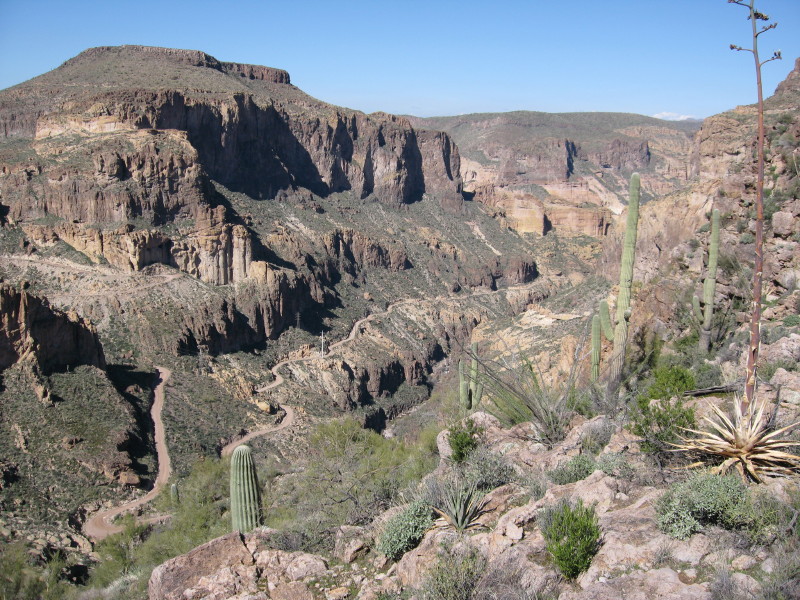 |
| One of the smaller dangerous parts of the trail |
 |
| Map of the Apache Trail |
The
Apache trail was originally a stagecoach trail that ran through the
Superstition Mountains. It was named after the Apache Indians who used the
trail for traveling purposes; however the trail has served humanity for more
than a millennium. The trail links Apache Junction at the edge of the greater
Phoenix area with Theodore Roosevelt Lake, and travels through the Superstition
Mountains as well as Tonto National Forest. The trail has supposedly been
around and regularly used for transportation purposes since almost 900 A.D
The
first step on taking this journey is to actually get to the beginning of the
trail, which isn’t particularly entertaining. The beginning is right after the
town of Tortilla Flat. From the metro Phoenix area it took my family and I
about 2 hours to reach. On the way we got small teases of the beauty we would
see later on while driving the trail, such as large rolling hills and lots of
the flora that the desert has to show, including cacti, for as far as the eye
could see. After a while we began to experience the very intense mountain
driving, which brought us down to a grueling 20 MPH just trying to avoid
driving off the sides of the cliffs we were on. This was probably the most
boring part of the trip because we were going so slowly, we were on a paved
road, and there were still lots of cars, RV’s, and trailers with boats all
about. I didn’t have that feel of being truly disconnected from society, which
is what I was hoping for and expecting.
 |
| The (Very) Small Town of Tortilla Flat |
A
quick bathroom break and buying some waters later, we were back on the trail.
After about 10 more minutes of driving we reached the beginning of the dirt
only trail, and after looking around taking in all the natural beauty, I
realized I had the feeling I wanted of being truly detached from society. From
this point on we took the roof of our jeep off and I stood up to get a full 360
view of everything for the length of the drive. While taking lots of pictures and trying to ignore the intense heat on my back and face, it was
hard for me to imagine that this beauty didn’t even stop after 22 miles. It
went on and on and on for the whole length of the desert. Large mountains and
gigantic rock structures abound, it took me a while to actually become aware that
the road we were driving on was no wider than a few feet more of our jeep.
After realizing what we were actually driving on and taking a second to look
down, I almost got sick from the height of the drop that was no more than 4
feet to my right.
We
eventually reached the first “rest checkpoint” which consisted of two,
absolutely atrocious bathrooms. This was the one downside to the entire trip;
after passing Tortilla Flat, there is only this one bathroom stop, and it was
absolutely disgusting. So basically if someone planned to drive the trail, you
would need to go to the bathroom right at Tortilla, and then hold it all the
way to the Franklin Roosevelt Lake, which is a LONG 22 miles if you have to go
to the bathroom. Aside from the bathrooms however, this is the first spot we
stopped at and were able to walk around on top of a massive plateau that had
huge ravines all around it. Echoes carried for what sounded like miles, and you
couldn’t see a sign of life or civilization if you tried, we were truly in the
desert.
 |
| The "Rainforest" Ravine/Valley |
 |
| The first long stretch of flat land in a while |
This
picture is the beginning of the flat trail we began once reaching the bottom of
the ravine. It allowed us to speed up to about 45 MPH while still getting some
nice wind to cool us off, and still getting a great view of the mountains. It
was along this road that we met our first, and only other car on the whole
trail, someone heading the other way. Saying it was a hassle to make sure that
neither one of our cars drove off the road while trying to pass each other
would be an understatement.
 |
| The Apache Lake alongside The Apache Trail |
Overall
the Apache Trail is one of the most beautiful trails I’ve ever seen in my life,
and something I think everyone who believes that a desert is just flat land and
cacti needs to experience and see; as well as everyone else that enjoys natural
beauty. Given the trails length, it is definitely something you want to clear a whole day for. The only possible downsides are that you do need a vehicle with
four/all-wheel drive, otherwise you wouldn’t be able to handle the dirt trail,
and that there are no bathrooms along the dirt part of the trail. But otherwise
the experience was amazing, and I don’t think I will ever be able to go
anywhere in my life and feel the sense of just being away from everything as I
felt that day. The natural beauty is everywhere, and every site, with the
exception of the cliff drops, just makes you stare in awe at it. It was
definitely a trip that I will never in my life forget, and hopefully take my
kids along the path one day as well so they can experience the same feelings I
felt that very day.
Resources
Hedding (2006) "Driving the Apache Trail."
Wikipedia
AmericanSouthwest (Unknown) "The Apache Trail"
http://www.americansouthwest.net/arizona/apache_trail/
Perkins (2006) "Scenic Drive: Apache Trail"
http://www.azcentral.com/travel/drives/articles/2006/06/14/20060614fav-apachetrail-CR.html
Perkins (2006) "Scenic Drive: Apache Trail"
http://www.azcentral.com/travel/drives/articles/2006/06/14/20060614fav-apachetrail-CR.html